Article · 12 May 2026 · By Mike
Flood Risk in El Niño Years: What to Know
El Niño reduces average rainfall but does not stop flooding in Australia. Here is what east coast property owners need to know before winter arrives.

El Niño conditions do not eliminate flood risk in Australia — they shift the statistical probability of rainfall while leaving several damaging flood mechanisms entirely intact. For property owners on the NSW coast, in southern Victoria, and across southeast Queensland, the winter storm season poses meaningful risk regardless of which ENSO phase is active. The time to address that risk is May, before the peak window opens.
What does the ENSO shift mean for Australian weather?
The Bureau of Meteorology declared La Niña officially over on 31 March 2026. A neutral ENSO phase has since held, with forecast models pointing to El Niño conditions developing sometime between late autumn and mid-winter. For many property owners, that sequence sounds like good news — drier conditions, fewer floods, lower urgency around preparation.
The reality is more complicated. La Niña brought three consecutive wet seasons and significant flooding across Queensland, New South Wales, and Victoria. Those seasons set a baseline for property damage — thousands of homes and businesses that have already been repaired, restocked, and reset. Owners who spent 2023 and 2024 dealing with flood aftermath understandably welcome the prospect of a drier cycle.
But the Bureau of Meteorology's own seasonal outlooks carry a critical caveat that rarely makes headlines: forecast models lose accuracy during autumn due to what climatologists call the "autumn predictability barrier." This window, running roughly from March to May, is the period when sea surface temperatures in the equatorial Pacific are least stable and hardest to forecast. Confidence in El Niño or La Niña predictions increases substantially through June and July. In practical terms, the transition period — right now — carries the greatest forecast uncertainty in the entire ENSO cycle.
Why flooding still happens in drier years
The ENSO pattern affects probability, not possibility. Several mechanisms produce significant flooding in eastern Australia that operate largely independently of whether El Niño is active:
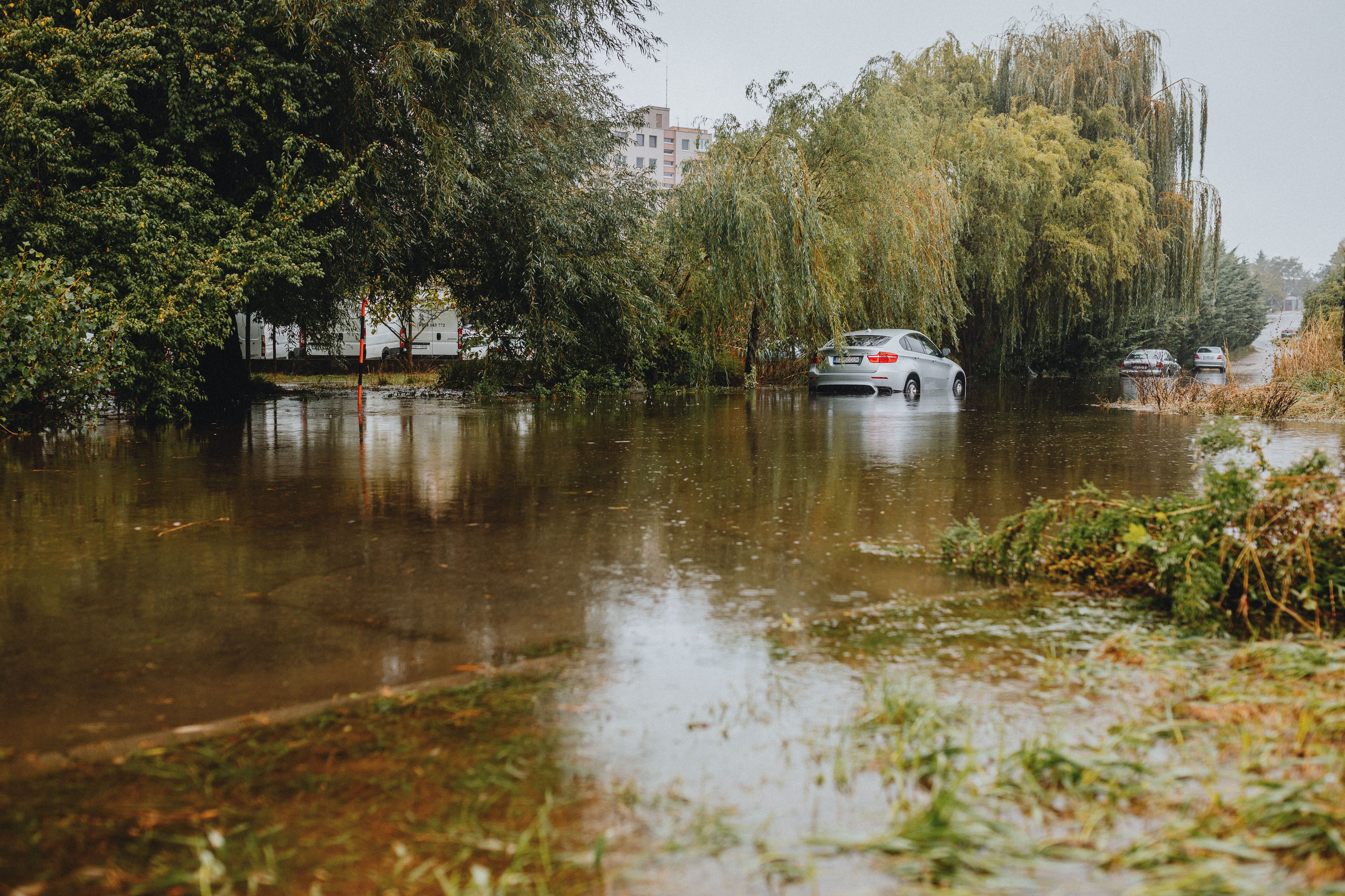
East coast lows develop over the Tasman Sea through baroclinic instability — a process driven by temperature contrasts between air masses, not tropical ocean heat. They can deliver extreme rainfall over 24–48 hours to coastal NSW, the Hunter region, and the Illawarra regardless of the prevailing ENSO phase. Some of the most damaging east coast lows in Australia's recorded history have occurred during El Niño periods.
Cold fronts and winter storms produce a consistent pattern from May through August as polar air pushes northward across southern Australia. These systems drive intense rainfall over Melbourne, the Otway Ranges, regional Victoria, and Adelaide. Flooding from cold-front events is driven by frontal dynamics and moisture drawn from the Southern Ocean — not tropical sea surface temperatures. The Victorian SES issued multiple flood watches across the Central, North Central, and Gippsland districts as recently as early May 2026.
Cutoff lows form when upper-atmosphere systems become isolated from the main jet stream and stall over a region. These systems produce prolonged, localised heavy rain over periods of 24–72 hours. They are particularly common in autumn and early winter, and are largely unpredictable at seasonal timescales. Even an accurate El Niño forecast provides no skill in predicting when or where a cutoff low will form.
Urban overland flow occurs when even modest rainfall of 20–30 mm in one hour exceeds the capacity of stormwater drainage. Most Australian cities were designed around drainage standards that are now insufficient for the intensity of individual storm cells. This kind of flooding is independent of river levels and is not captured by catchment-level warnings. Properties on low ground, at the base of slopes, or downstream of large hard surfaces face real overland flow risk in any season.
Which regions face winter flood risk in an El Niño year?
El Niño's drying effect is strongest across inland northern and central Australia. It is weakest — and sometimes reversed — along the coasts of southeastern Australia. The Australian Institute for Disaster Resilience notes that regional flood risk profiles vary considerably within a single ENSO phase, and that coastal communities should not assume reduced risk from an El Niño signal.
In practice, the following areas retain meaningful winter flood exposure regardless of ENSO phase:
- Coastal NSW — Newcastle, Central Coast, Sydney, Illawarra, and Shoalhaven are exposed to east coast lows and blocked rainfall events. Annual flood risk for ground-floor and below-street-level properties does not follow the ENSO signal.
- Southern Victoria — Bayside Melbourne, the Yarra Valley, outer eastern suburbs, and Gippsland receive cold-front and cutoff low rainfall that tracks eastward from the Southern Ocean. These systems are driven by southern hemisphere jet stream dynamics rather than tropical temperatures.
- Southeast Queensland — Coastal communities from the Gold Coast north through Brisbane's bayside suburbs face east coast low risk through autumn. Even in a dry El Niño year, an individual event can deliver 150–200 mm in 24 hours to these catchments.
How to assess your property's actual risk
Assessing flood risk at the property level requires looking at site-specific factors rather than the seasonal outlook. A walk-around in dry conditions is the most useful first step.
Drainage gradient. Stand outside and observe where water naturally runs during moderate rain. Any doorway, access gate, or ground-level opening that collects runoff from an adjacent slope or paved surface is a flood-entry candidate.
Stormwater infrastructure age. Older urban areas — particularly inner-city and interwar residential suburbs in Sydney and Melbourne — were built with drainage designed for historical rainfall intensities that are now regularly exceeded. Ground-floor entries in these precincts face overland flow risk in events that would not cause flooding in newer suburbs.
Below-street entries. Basement car parks, sunken garage entries, and shopfronts set back behind a kerb are particularly vulnerable because they collect surface water from the street. Even 30–40 mm of rainfall can overwhelm a sunken entry in a dense urban block.
Flood history. Properties in streets or postcodes with documented flood history are statistically more likely to flood again, regardless of the seasonal outlook. Check council flood maps and historical records, not just seasonal ENSO forecasts.
Matching protection to your property before winter
The right product depends on what openings need protection and how quickly deployment needs to happen.
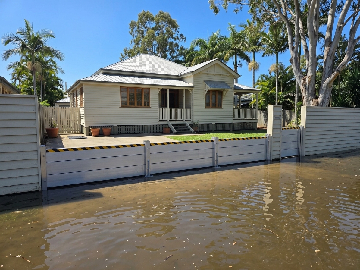
For homes and small businesses with standard door widths and garage entries, aluminium demountable flood barriers are the practical default. A set covers openings up to 3,000 mm wide, deploys in under 10 minutes with one person, and lasts 25 or more years with minimal maintenance. From $890 per set, they suit properties that want reusable protection without structural modifications.
For quick deployment at secondary entry points — side gates, cable penetrations, utility entries, or gaps where a rigid barrier cannot sit flush — water-activated sandbags are the most flexible option. At $39 per four-pack with free Australia-wide shipping, each bag stores flat and expands in 2–3 minutes on water contact, swelling from 270 g to 18–22 kg through a sodium polyacrylate core. No sand, no filling equipment, no advance preparation.

For properties that may be unoccupied when a warning arrives, an automatic flood barrier system provides passive hydrostatic protection from $4,500, activating as water rises without power, sensors, or staff presence.
The most common approach for residential and small commercial properties is a combination: rigid aluminium barriers at primary entries, and water-activated sandbags to address irregular gaps and secondary access points that rigid systems cannot cover.
Why May is the right time to act
Flood protection equipment takes time to source and deliver. Standard products ordered now arrive within a few business days. Custom-engineered solutions may need two to three weeks. By May, the main winter storm window is weeks away. By June, some events have already passed.
Acting in May also means installation and a dry-run deployment can happen without any pressure. Barriers fitted now can be tested, adjusted, and stored correctly — ready to deploy when the first severe weather warning arrives. A rehearsed installation under calm conditions takes minutes; the same task under time pressure with unfamiliar equipment takes much longer.
Reviewing your site before winter
A practical walk-around checklist:
- Low doorways and entries where surface water naturally drains toward the building rather than away from it
- Garage roller doors with bottom seals that are cracked or compressed flat — these provide little meaningful resistance to water under pressure
- Sunken driveways that funnel stormwater toward the garage rather than to the street
- Adjacent hard surfaces or structures that concentrate runoff toward your property during heavy rain
- Secondary entry points — side gates, service doors, cable entries — that are often overlooked in flood planning
If any of these apply, the opening is a barrier candidate. Identifying them now, with no urgency, is the most productive starting point for the season.
For properties with more than one at-risk entry, or for commercial sites needing a full opening survey, contact the team for a product recommendation.
Recommended next step
Match the guide to a flood barrier option.
These are the product pages and guides most relevant to this topic. Use them to compare flood barriers Australia-wide, then request a site-specific recommendation.